 |
|
|
Volume XIII |
September 2008 |
Number IX |
|
|
A River Used to Run Through It By Mark SchillerWater Update By Kay MatthewsActivism and the Local Nuclear Weapons Industry By Sheri Kotowski, Embudo Valley Environmental Monitoring Group |
Review of Miranda Canyon Preserve by Wildlands Watch By Kay MatthewsForest Update By Kay Matthews |
A River Used to Run Through ItBy Mark SchillerIn 2007 the conservation group American Rivers named the Santa Fe River the "most endangered river in the United States." In the statement that conveyed that designation the group noted, "The Santa Fe [River] suffers from chronic water extraction that leaves its bed a dry ditch most of the year." As everyone knows, the City of Santa Fe itself is responsible for the dewatering of the river. It captures the vast majority of the river's surface water in reservoirs in the mountains above the city to provide forty percent of residents' domestic water needs. The city also utilizes much of the sub-surface water associated with the river through a group of wells adjacent to the river that supply an additional thirty percent of Santa Fe's domestic needs. 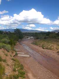
The Santa Fe River near Frenchy's Park after a reservoir release by the City of Santa Fe In an April 2007 letter to city residents Santa Fe Mayor David Coss responded to the endangered designation by stating, "The City of Santa Fe uses the water rights it owns to provide for the community's needs. . . . [O]ne of the ways Santa Fe may be able to bring life back to the River is through purchasing or leasing water rights for the River. If our community joins together and sets aside regular donations for the River, we will be able to provide water to keep our River healthy. . . . [W]hen there is water in the River, it becomes the community's favorite natural area for children, dog walkers, fisherman, tourists and even kayakers." In his State of the City address Coss went on to say, "I am happy to announce today that I am proposing 1,000 acre-feet of water [an acre foot is approximately 326,000 gallons] be dedicated to the Santa Fe River by next spring through adoption of the city's Long Range Water Supply Plan." All of the mayor's "feel-good" rhetoric, however, is haunted by a dirty little secret: the city "appropriated" most of its surface and sub-surface water rights from the acequias and domestic wells of the community's poorest residents without permission and without compensation. A 1996 report by the Public Service Company of New Mexico ("Two Mile Dam and Reservoir: The Final Documentation of the Life and Breach of a Public Resource" authored by Karen Lewis and edited by Douglas G. Campbell), which formerly administered the city's water system, documents this disturbing history. In 1880 the primarily Anglo Santa Fe Board of County Commissioners empowered the Santa Fe Water and Improvement Company ". . . with the exclusive right and privilege of erecting dams and reservoirs for impounding water on the Santa Fe River." In other words, the City unilaterally granted itself the right to divert 1,540 acre feet per year for the purpose of forming a domestic water delivery system, without the consent of downstream irrigators who had a prior right to the water. The primarily Hispano acequia parciantes, who depended on the river's water to irrigate their gardens and orchards and operate their grist and carding mills, did not take this decision lying down. A June 23, 1881 article in the Daily New Mexican states, "Yesterday afternoon the difficulty between the property owners along the Santa Fe river came near resulting in a fight between a lot of Mexicans [note the racist undercurrent when referring to City residents who had become American citizens more than 30 years before] and the hands engaged in laying the pipes from the city to the reservoir." The article goes on to note that the protesters were armed and the County Sheriff and City Chief of Police had to be called. According to the article the protesters were "very bitter in their expressions against that officer [the sheriff] and openly accused him of being interested in the works himself, and of being influenced in his action on that account." The sheriff, however, managed to disarm the protestants and the article concludes by saying, "The Mexicans have been made to understand that if they wish to prevent the construction of the water works they must do so by legal procedure and not by force." Apparently those "Mexican" residents took the sheriff's advice to heart because that same month, the Daily New Mexican published a statement eloquently stating their case: We, the majority of the people of Santa Fe, declare and maintain that whereas we have been entitled to the water in the Santa Fe river since the conquest of this country, have used it for the purpose of irrigating our fields and quenching the thirst of our families, that the water has been given to us by the sublime will of God, and Whereas some individuals have associated with a view of controlling the water of said river by building dams in Santa Fe Cañon and to interrupt the free course of the current with the purpose of retaining and speculating with the water by selling it to the poor people of Santa Fe, thus damaging the whole community, and Whereas the people of Santa Fe will in no way permit such proceedings, be it: Resolved that the people of Santa Fe will by all legal means cause the said water works company to stop abusing and appropriating the rights belonging exclusively to the people, will prevent their converting the same to their own pecuniary welfare, leaving the community helpless and subject to their charity, and depriving them of all the sacred rights which nature has given them merely to satisfy ambition. The people of Santa Fe in meeting assembled and in view of the injustice and prejudices which the said company will cause to Santa Fe people by stopping the free course of the water in the river and prevent them from irrigating their lands hereby. Resolved that the water company is hereby cautioned to stop all work in the cañon of Santa Fe river interrupting the current of the stream and injuring the community, which action is herby declared an outrage on the people and that said community will in no way permit such action. Resolved, that the people of Santa Fe are and will be opposed to consenting that the water works company shall abuse the people and appropriate to themselves their rights which they consider a legal and divine gift from Almighty God, and which rights belong and shall belong to the people, and who will in no way permit that any company shall jump their rights. Resolved that the Hons. Sol Spiegelberg, Jas. Donovant, Nasario Gonzales, Board of County Commissioners and Hon. Gaspar Ortiz, Probate Judge in and for Santa Fe County, are authorized to represent the people of Santa Fe and are required to arrange the matter with the water works company, avoid their control of the water of Santa Fe river which they resolved to do in prejudice of the community and to caution said company to let the said waters run for the benefit of the people, who will use all legal rights with this object in view. Resolved, that the Hon. Juan Garcia, C. Martinez of Precinct No. 3, Aniceto Abeyta and B. M. Reed of Precinct No. 4, and José Antonio Romero of Precinct No. 5 are herby appointed a committee to cooperate with the County Commissioners and the Probate Judge in reference to the settlement of the matter. Resolved, that we will employ all legal means to defend our rights and will, if necessary, ask the protection of the executive department. Resolved that we swear to stand by the constitution and the form of government and protest against violence, and request the proper authorities to enforce the laws. Resolved, that if said company persists in carrying out their works they shall be considered open enemies of the public.
Other articles in the Daily New Mexican detail a history of broken promises to protect and compensate Santa Fe River water rights owners by both the city and the water utility. Another June 1881 article documents a meeting between the citizens' committee and the water utility directors in the Probate Judge's office during which the water works board gave ". . . the necessary assurance that the company will not interfere with the flow of the Santa Fe River day or night and will remunerate all persons whose property is in any way injured by the laying of the mains." The article went on to assert, "The water works company has acted in a liberal, fair-minded way and acceded to all the demands of the other side. They are acting in good faith and there is every reason to believe that the trouble is virtually at an end." Whether this agreement was initially honored is unknown, but we do know that by 1893 there was insufficient water for both the water works and the acequias to operate simultaneously. According to the previously cited Public Service Company of New Mexico report, on June 26th of that year the water utility limited irrigation to between 6:00 and 9:00 a.m. On July 5th the water utility disallowed the diversion of water for irrigation all together. That policy, as you can imagine, did not sit well with downstream users. A Daily New Mexican article from July 17th, however, states "all differences" between the acequia parciantes and the water utility "were amiably and satisfactorily adjusted" through an arrangement by which the water utility and the acequias initiated a rotation for diverting the river's water four days each. A strategy was being established, however, as the city and its water utility gradually impounded more and more of the river's water (Two Mile Dam was completed in the early 1890s followed by McClure Reservoir, 1927-1928, and Nichols Reservoir, 1941-1943) that marginalized downstream senior agricultural water rights owners. In 1925 the Santa Fe City Council once again unilaterally enacted an ordinance that directed its water utility (New Mexico Power Company) to construct McClure Reservoir to satisfy the needs of its growing population with the proviso that it maintain "so far as feasible the normal flow in the channel of the Santa Fe River to the extent of valid existing prior private rights therein." The State Engineer then issued New Mexico Power Company a permit to divert 3,500 acre feet of water per year with the condition that the diversion "is not to be exercised to the detriment of any other others having valid prior and existing rights to the use of this stream system." In practice, however, the City used as much water as necessary, disrupting the river's flow and daring the poor, largely disenfranchised senior water rights owners to undertake the costly process of suing a municipality with deep pockets. The vast majority of acequia parciantes were forced to abandon their farming and ranching operations as water delivery became less and less dependable, thus abandoning their senior water rights and allowing the City's junior water rights to prevail. Although other factors played a role in water rights abandonment (familial subdivision of irrigated land for residential use; the paving over of acequia infrastructure because of municipal development; and heads of households going off to fight in World War II), it seems clear that the City's presumption that it had a "paramount" right to the water was the central issue. According to the 2002 "Santa Fe River Watershed Restoration Action Strategy Plan" authored by Paige Grant of the Santa Fe Watershed Association, the complete dewatering of the Santa Fe River to the western limits of the City's environs did not occur till the late 1940s, "when the water demand in the City began to approach the supply available from the reservoirs above town." A 1988 study of the Santa Fe acequia systems underwritten by the City's Planning Department shows that the City's 1914 hydrographic survey included more than 30 acequias, ranging from the upper reaches of the watershed near present day McClure Reservoir down to the end of Agua Fria Street, were irrigating 1,340 acres of farm land and orchards. By contrast, the 1977 hydrographic survey indicated there were only four functioning acequias irrigating about 62 acres. By its own admission, the City has essentially dewatered an almost fourteen mile stretch of the river. Today only three acequias (Acequia Madre, Cerro Gordo, and Acequia del Llano) are in operation. These acequias, in the upper reaches of the City's east side, remain viable only because residents had the money and the wherewithal to fight the City in court. In 1989 Public Service Company of New Mexico (PNM), which formerly managed the City's water utility, asserted that it had a "paramount" right to expand the City's diversion to include all the surface water in the Santa Fe River in order to accommodate municipal development. In a precedent setting 1990 decision, however, District Court Judge Art Encinias ruled, "Since at least 1946, PNM has arrogated to itself an 'expanding' right &endash; heretofore unknown in the law &endash; in all of the surface waters of the Santa Fe River, effectively muscling out all down stream users. This conduct is based on a contrived 'grant' of a 'paramount' right in an ancient document which says nothing of the kind. Neither the 1880 grant from the Santa Fe Board of County Commissioners nor any other agreement between the County or City and PNM or its predecessors, conveys a right to PNM to the surface waters of the Santa Fe River. PNM has no authority to withhold any waters of the Santa Fe River except to the extent of its claimed rights as declared to the State Engineer and acknowledged by him, to wit: 5,040 acre feet of water annually. By denial of water to downstream users [here, the Acequia members], PNM has irreparably harmed them . . . ." So if City residents really value a functioning river they should thank their lucky stars that a few courageous acequia parciantes, including, but not limited to, Phil Bové, Herman Montoya, Ignacio Moya, and Booker Kelly, had the courage and fortitude to fight the City, which clearly was (and many believe remains) prepared to hand over all of the river's resources to the insatiable developmental interests that control City politics. Water UpdateBy Kay MatthewsIn 2007 Santa Fe County applied to the Office of the State Engineer to transfer water rights to 19 county wells to supplement its Buckman diversion rights. The Santa Fe Basin Water Association (SFBWA), a group of citizens concerned about the potential impact of the county wells on private wells and water resources in the county, filed a protest of the transfer applications along with approximately 250 other concerned citizens. The group later sent out letters to the other protestants asking them to consolidate their protests with the SFBWA, and about 90 people agreed to do so. The protest files have been turned over to the Administrative Litigation Unit at the OSE, although no hearing date has been set. According to SFBWA president John McGill, the group recently met with county representatives John Utton, Karen Torres, and Steve Ross, who told them that the county intends to use the 19 wells only as backup. The county estimates this will occur three years out of every ten, when the Rio Grande is low because of drought. Apparently the OSE is reluctant to approve the wells based on such little definitive information on the amount of water that will be yearly pumped, and the SFBWA wants the county to base its groundwater modeling on the maximum possible pumping from each well and to monitor the wells to protect and predict effects on existing wells. According to McGill, the county asked the SFBWA to drop its protest if it included some of the group's requests into its plans, but the SFBWA declined, stating that there is no guarantee that one County Commission's decision couldn't be overturned by another. The group wants to have a hearing before the OSE to present its case and have that agency or District Court set the conditions for the new wells. I contacted Santa Fe County Public Information Officer Stephen Ulibarri to find out whether the county had a specific plan regarding the use of the 19 wells, and he referred me to the county's water management web site, but I couldn't find any detailed information regarding the wells. He declined to provide any information regarding the protests, saying only "it's in litigation." According to Andrew Store of the OSE, a docketing notice will soon be sent out to protestants and applicants asking for hearing fees. Store will be holding a public meeting with the protestants to explain the hearing process (Victor Kovach has been appointed the hearing officer) and to determine which individual protestants have joined with the SFBWA and who wants to be represented pro se or by an attorney. Activism and the Local Nuclear Weapons IndustryBy Sheri Kotowski, Embudo Valley Environmental Monitoring GroupWith the support of community members, tribal and state government, and local organizations, the Embudo Valley Environmental Monitoring Group (EVEMG) has successfully established independent, citizen-based monitoring in the Rio Embudo Watershed for radionuclides and heavy metals associated with the nuclear weapons industry at Los Alamos National Laboratory (LANL). The impetus for this monitoring began one and a half years after the plume of the Cerro Grande Fire of 2000 settled over our watershed, when community members began asking questions concerning the effects of exposure to the plume of that fire. The fire burned a total of 45,000 acres of land, including 7,500 acres of LANL property known to be contaminated by past and on-going LANL activities. The unsatisfactory answer to our questions was there was no harm done to our communities by the fire. Many asked about the basis for that assessment. The answer was admittedly insufficient and flawed data. Many then asked, what could be done after the fact? "Nothing" was the official answer because there was insignificant background data to show any difference in local conditions pre-fire and post-fire. The database we have now built provides a scientifically sound baseline for radioactivity that will benefit surrounding communities in the event of radioactive releases, either accidental or because of LANL activities. After a series of dismal and frustrating meetings held in Dixon, people from the lower and the upper watershed came together to strategize on a plan to actively protect the watershed. While working directly with Picuris Pueblo and the Picuris/Peñasco Community Coalition, EVEMG was loosely formed. We brought our concerns to the Community Radiation Monitoring Group (CRMG). CRMG is a monthly public forum facilitated by the New Mexico Environment Department's (NMED) LANL Oversight Bureau. The Oversight Bureau is the state's watchdog for environmental surveillance at LANL. Participants in the forum include NMED, tribal governments, LANL, community organizations, and individuals. The CRMG mission is "To understand and communicate public health issues relating to direct penetrating radiation and radiation from airborne radioactive materials that result from activities at LANL." Through CRMG, EVEMG identified needs and developed technical air monitoring plans with NMED and LANL. We now work with other local groups we've met through CRMG that share our concerns about LANL air-borne contamination, and we continue to raise community awareness about these issues. Through on-going participation in CRMG, many layers of relationships have been fostered, and many other issues related to air-borne contamination such as prescribed burning on lab property, open burning and open detonation practices, and emergency preparedness have been raised for public input and participation. Not only are these meetings informational, they provide and inspire an avenue for activism. Topical issues brought forward by participants are the focus of the monthly public forums. Meetings generally rotate between Española and White Rock, with annual meetings in communities such as Santa Fe and in the Rio Embudo Watershed, in Dixon or at Picuris Pueblo. The latest concern is the 2007 EVEMG/NMED collaborative sampling project that found exceptional levels of cesium, plutonium, and strontium in a single soil sample taken at the top of the watershed near the Las Trampas Lakes. These are dangerous radioactive materials generated predominantly by the research, manufacturing, and testing of nuclear weapons. This detection, together with the indoor residential dust survey (2006) finding of strontium at a local residence in Llano, are issues that need community support for a strategy developed by local, independent, and agency experts. On November 12th, Picuris Pueblo will be hosting the CRMG meeting from 10 am to 12 noon in the big room at the tribal government building. Indoor and outdoor air monitoring programs as well as other community concerns will be the topics for discussion. Local public participation is encouraged and necessary in order to address the impacts of the nuclear weapons industry in our watershed. Community Radiation Monitoring Group Meeting Hosted by Picuris Pueblo and the Picuris Pueblo Environment Department (PPED) Craig Quanchello, Governor Cordell Arellano, PPED Director Cheryl Archuleta, PPED Assistant Director PPED Wednesday November 12, 2008 10am-12noon Picuris Pueblo Tribal Government Building, Picuris Pueblo
For more information please contact: Sheri Kotowski Embudo Valley Environmental Monitoring Group P.O. Box 291 Dixon, NM 87527 505.579.4076 serit@cybermesa.com
|
ANNOUNCEMENTS• The High Road to Taos Art Tour will take place on successive September weekends, the 20-21st and the 27 -28th. Artists from Chimayó up through Córdova, Truchas, Ojo Sarco, Las Trampas, El Valle, Chamisal, Rio Lucio, Peñasco, Llano San Juan, Llano de la Llegua, Vadito, and Sipapu will show their paintings, sculpture, pottery, jewelry, carvings, furniture, and more. Demonstrations and workshops in many of these arts and crafts will also be presented at some of the venues. For more information go to: http://highroadnewmexico.com/index.html.
• The Native Earth Bio Culture Council in conjunction with the Pueblo of Tesuque farm program is hosting the third annual Symposium For Food and Seed Sovereignty September 26-27, 2008. The Symposium will include internationally renowned speakers as well as local and regional experts in the areas of food security and sustainable ecology and a heritage seed exchange. The Symposium will also host panels on youth issues in the 21st century, food and nutrition, water issues and traditional farming, land restoration, and medicinal herbs. An important theme will be pro-active community response in support of sustainable communities, ecologies, health, and indigenous spiritual practices. There is a vendors' market featuring natural earth friendly products, information, and services. The public is invited. For more information and to register go to: www.foodandseedconference.info or call 505 955-7723.
• The Dixon Studio Tour will take place on November 1 & 2 from 9 a.m. to 5 p.m. Forty-one artists in the Dixon/Embudo/Cañoncito area will sell their paintings, sculpture, ceramics, jewelry, furniture, photography, and more. This is the grandfather of all northern New Mexico studio tours, and also features the Vivác and La Chirapada wineries as well as Stan and RoseMary Crawford's El Bosque Garlic Farm.
• On Wednesday November 12, the Community Radiation Monitoring Group will meet from 10 a.m. to 12 p.m. at Picuris Pueblo. The CRMG is a public forum facilitated by the New Mexico Environment Department and Los Alamos National Laboratory (LANL) Oversight Bureau. The mission of the CMRG is to understand and communicate public health issues relating to direct penetrating radiation and radiation from airborne radioactive materials that result from activities at LANL. The local group, Embudo Valley Environmental Monitoring Group (EVEMG), has worked with the CRMG for six years on regional issues from the perspective of land-based communities situated downwind from LANL. Please look for an article available online in October on the La Jicarita News web site (lajicarita.org) and in the November issue of the paper about EVEMG's work in the Rio Embudo Watershed and the importance of community participation. For more information, please attend the Picuris/Penãsco Community Health Fair on October 11th from 8-12:30 p.m. at Picuris Pueblo or call 505 579-4076. La Jicarita News will combine the October and November issues of the paper, so look for us again around mid-November.Review of Miranda Canyon Preserve by Wildlands WatchBy Kay MatthewsA Taos based non-profit environmental group recently released an Environmental Impact Review of the proposed development in Miranda Canyon by the Weimer family, heirs to Alexander Gusdorf. The group has submitted its review to the Taos County Planning Department, which oversees the Miranda Canyon application (see La Jicarita News October 2005). Carol Rosendahl, director of Wildlands Watch, told La Jicarita that her small organization came together to try to address the widespread development that is occurring in many wildland places all over the West (the groups also works on issues in California). Rosendahl, whose background is in geology and environmental science, spent a year compiling the study, which focuses on analyses of: scenic and natural resources in the area; project compatibility with existing uses; historical resources; watershed degradation; wildfire potential; emergency egress routes; and federal regulations. Rosendahl also compiled an actions recommendations report that provides information on how to effectively fight developments like the proposed Miranda Canyon Preserve, which she is sending to various environmental groups and activists in the Taos area. Below is a synopsis of the Environmental Impact Review. The 5,000 acre Miranda Canyon Preserve is located in a remote area of forest and meadow wildlands surrounded by national forest, terminating on the south end at Picuris Peak. The review claims that the proposed development will not only impact wildlife through loss of habitat, "but it slices through the heart of the area, cutting across wildlife corridors that access meadow food sources and the only wildlife watering source in the Miranda Creek. Understory scouring of vegetation for fireproofing residences will further reduce wildlife food sources." Sixty per cent of the project boundary is shared with Carson National Forest. The Forest Service Mission Statement lists the greatest threats to health and value of national forest lands as forest fires, unmanaged recreation, and human settlement into formerly wild areas. Currently, the existing uses on the Miranda Canyon property and the surrounding national forest lands are the same: wildlife habitat, wildlife food sources, wildlife watering areas, wildlife nesting areas, wildlife corridors, municipal watershed, and headwaters to Taos Valley streams and acequias. Wildlands Watch argues that "Miranda Canyon development, which includes grading, roads, structures, lights, traffic, human activity, and encroachment is incompatible with existing and historic uses on the site and in the neighborhood of the site. It could further be argued that the development represents not only an appreciable degradation of scenic resources on adjacent remote Federal lands but also a threat to the wildlife on those lands." Wildlands Watch believes that the archeological and historical sites in the proposed development have not been adequately inventoried, documented, mapped, or protected. The most critical and well known significant site is that of the El Camino Real route that runs through the heart of the development. This is the route that for 300 years was the only road that connected Spain's colonial capitol in Mexico with the Spanish settlement and pueblo communities in New Mexico. It traverses north through Carson National Forest before crossing over a ridge in the Picuris Mountains not far from Picuris Peak and dropping into Miranda Canyon, where it runs the length of the project property. This is one of the few places you can follow the original route of El Camino Real and "be in a landscape virtually unchanged since the 16th century." In October 2000, the U.S. Congress designated portions of El Camino Real as a National Historic Trail (from El Paso to San Juan Pueblo), and in September of 2004 the Bureau of Land Management and the National Park Service finalized the Comprehensive Management Plan for El Camino Real to protect important scenic values. Wildlands Watch claims that the additional 200 miles of the trail, to its northern terminus at Taos Pueblo, should also be included in that historic designation and that the Comprehensive Management Plan should be a template for its protection. In the eventuality of its designation, there are a number of options in the CMP for protection of segments that cross private lands, including site certification, easements, and land purchase or exchange. 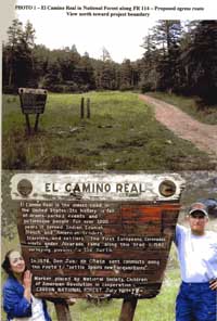
Watershed Degradation The bulk of the Taos County municipal watershed lies within the proposed development. Wildlands Watch believes a project of this size, "cut deep into the Miranda Canyon headwaters endangers this watershed in several ways": road building will cause erosion, and 150 subdivided parcels will decrease the ability of the watershed to absorb, filter, and store water. The potential for a "megafires" in the proposed subdivision is one of Wildlands Watch biggest concerns. The development pattern of houses dispersed through extreme fire zones is causing megafires all over the country that are stretching state resources to their limits. In 2007 California wildfires blackened 400,000 acres, destroyed 2,000 homes, and forced the evacuation of one million people. The combination of isolated homes surrounded by natural vegetation "are the most dangerous combination for fire," particularly in the prolonged drought the Southwest has been experiencing. Wildlands Watch believes that the subdivision's "relatively narrow knife edge of development, bordered on both sides by fairly steep, inaccessible terrain," with only one way in and one way out (see next section on Emergency Egress Routes) would create an extremely difficult fire fighting scenario. Prevailing winds could easily spread the fire onto surrounding national forest land. Entrance to the subdivision is through Llano Quemado. There are three proposed egress routes through the national forest off of SH 518, using Forest Road 476 and/or Forest Road 114. Wildlands Watch believes all three routes are problematic. Taos County Subdivision Regulations, Appendix D &endash; Fire Protection Regulations, requires fire access roads to be all-weather roads with a minimum width of 22 feet and a maximum 12 per cent gradient. Wildlands Watch claims that all the upstream egress lands slopes are 20 per cent or greater. A Special Use Permit would be required to override the Fire Protection Regulations. The three egress routes also traverse portions of El Camino Real; the Picuris Peak egress route on FR 114 would require upgrading FR 114, currently a four-wheel drive only road, and according to Wildlands Watch, obliterate a segment of El Camino Real. The two other proposed egress routes, through the Vallecitos area on national forest land, would impact elk and other wildlife and would require turning what are essentially trails into roads, also impacting El Camino Real. I called Camino real District Ranger John Miera about the egress routes across Forest Service land. He said that while Todd Barbee, Miranda Canyon Preserve Project Manager, contacted him last summer about the project, he hasn't received a formal request for a Special Use Permit, which will be reviewed under the NEPA process. Under those terms, the project will have to prove there is no viable alternative for egress. I also spoke briefly with Taos County Planner Edward Vigil, who is reviewing the Miranda Canyon Preserve application. He said that the application had been "deemed incomplete" by several of the state reviewing agencies, and had been sent back to the Weimer family for revision. The agencies that have submitted "adverse" opinions or asked for clarifications are: the Office of the State Engineer; Taos Soil and Water Conservation District; the New Mexico Department of Transportation; and the New Mexico Office of Cultural Affairs (Vigil said this office was only asking for certain clarifications). I received this information from Vigil too late in the day to contact the individual agencies to find out what their concerns are. La Jicarita News will follow up on the project application in the November issue. Vigil also told me there will be three hearings on the application. A preliminary plat hearing will probably be held by the Taos County Planning Commission in November (this is a public hearing), after the applicant has addressed the issues raised by the consulting agencies or decides to go ahead despite the "adverse" opinions. If the preliminary plat is approved, the application will then go before the County Commission, and a request for final plat approval will also be heard before the County Commission. According to Todd Barbee, these agency "adverse" opinions are based on "relatively minor points, including requests for additional disclosure statement language, clarifications, exhibits, etc. We are in the process of addressing those points and should have final opinions from respective agencies in the next 45 days." He also dismissed Wildlands Watch's concerns as "misinformation, pseudoscience, and egregious deviation from fact." Instead of addressing the review "point by point," he said that the "wide range of regulatory agencies and credentialed professionals who have been tasked with reviewing all aspects of the Miranda Canyon Preserve [will] determine if the proposal complies with the stringent local, state, and federal regulations it is subject to. . . . Any legitimate questions, comments or concerns that the public may wish to raise will be respectfully heard and addressed by the project team at the public hearing held before the Planning Commission." Forest UpdateBy Kay MatthewsA few weeks after the August issue of La Jicarita News was mailed, with the article about the controversial La Joya prescribed burn, the forest prevention technician from the Camino Real Ranger District came through El Valle distributing fliers regarding additional prescribed burns scheduled for areas in the vicinity (La Joya again, West Entrañas, Montes, and El Valle). I happened to be out on the road and we had a conversation. We discussed the fact that the La Joya community felt the Forest Service had failed to keep its word about the extent and type of burn the agency planned to do in the thinning area. We agreed that it would be better if the Camino Real Ranger District oversees the proposed burns this time instead of the Hot Shot crew from the Supervisor's Office. She said she had forwarded a copy of La Jicarita to the Supervisor's Office (the office is already on the mailing list) and suggested to the Public Information Officer, Dorotea Martinez, that the Forest Service set up a meeting with folks in the affected communities to discuss the proposed burns. So I called Martinez, who referred me to Kathy DeLucas, Public Affairs Officer, who is in charge of setting up meetings regarding the proposed burns. Martinez and I discussed the previous lack of communication between the communities and Camino Real District and Supervisor's Office. While she said the Forest Service accepted blame for this situation, she also told me that their resources are stretched to the limit because of budgetary constraints. These constraints will also influence what resources are available to handle the proposed prescribed burns: there is not enough district personnel to handle the burns, and it is likely that personnel from the Supervisor's Office or other districts will be called in. DeLucas told me that she and Camino Real District Ranger John Miera have been discussing how best to communicate with folks in the communities regarding the prescribed burns. Rather than holding one large community meeting they are leaning towards organizing field trips to the proposed burn sites. DeLucas agreed that the forest needs to recreate some of the outreach that was done under the Collaborative Stewardship program back in the mid to late 1990s when Crockett Dumas was district ranger. When I spoke with District Ranger Miera he told me that the La Joya and El Valle prescribed burns have been postponed, and the West Entrañas and Montes areas will be burned this month. While he defended the La Joya burn from an ecological standpoint &endash; that all the objectives of the prescribed burn were met, he did say, "Where I fell short was on the social permission of the community." He agreed that the district needs to improve its outreach to the communities and has met with Max Córdova of Truchas and environmental activist Joni Berde, who also complained to him about the La Joya burn. Miera agreed that all the communities in the district have their own identities and concerns, and it's important for him to develop relationships with community leaders who can facilitate communication with other community members. Córdova reiterated his request that Miera hold "ranger days," during which community members can visit sites of Forest Service or community concerns, such as the prescribed burns, and discuss them with Forest Service staff. The district has targeted between 600 to 800 acres of prescribed burns this year. The approximately 300 acre West Entrañas area, which has been burned previously, will be a low intensity maintenance burn because there is little slash on the ground. The Montes area, containing approximately 160 acres, hasn't been burned previously but because of the green vegetation, high humidity, and lower winds than in the La Joya burn, it will also be a low intensity burn. Two more prescribed burns are planned for the Pot Creek area: Vallecitos, approximately 200 acres; and Turkey Park, approximately 140 acres. Miera said he would try to ensure that the district fire manager make contact with affected communities before the burns and be on site for the burns as the point person for the communities.
|
Home | Current Issue | Subscribe | About Us | Environmental Justice | Links | Archive | Index
Copyright 1996-2006 La Jicarita Box 6 El Valle Route, Chamisal, New Mexico 87521.