 |
|
|
Volume X |
October 2005 |
Number IX |
|
|
La Jicarita News: 10 Years OldANNOUNCEMENTSBook Review: Adaptive Governance: Integrating Science, Policy, and Decision Making By Ronald D. Brunner, Toddi A. Steelman, Lindy Coe-Juell, Christina M. Cromley, Christine M. Edwards, and Donna W. Tucker Reviewed by Kay Matthews |
Tesuque Pueblo Files Suit
Northern New Mexico Ranchettes:
|
|
Tesuque Pueblo Files Suit to Stop Santa Fe Ski Area ExpansionOn August 31 Tesuque Pueblo filed a lawsuit in federal district court charging the Santa Fe National Forest with unlawfully permitting the expansion of the Santa Fe Ski Area into the Lake Peak/Deception Peak area. The lawsuit cited three reasons for this action: 1) The Forest Service's approval of this project will substantially impair the Tribe's ability to carry out religious and ceremonial practices in and near the ski area; 2) The Forest Service expanded the special use permit boundary and uses for the ski area without following the procedures for permit amendments required by federal and internal Forest Service regulations; and 3) The Forest Service's approval of changes to the lift design violates the procedural requirements of the National Environmental Policy Act (NEPA). The Santa Fe Ski Area has already begun work on a new triple chairlift that will extend over 5,500 feet into the Lake Peak/Deception Peak area to an elevation of 12,074 feet and have a capacity of 1,800 passengers per hour. The lawsuit asks the Court to enjoin the construction and/or operation of the new lift; declare the Forest Service decision to permit the work unlawful; and remand the decision for approval to the Pueblo. The suit goes on to detail the Tribe's complaints. With regard to impairing its ability to exercise its religion, the suit asserts "Tribal members make pilgrimages to Deception Peak to fulfill religious obligations and communicate with the spirit world. As part of the pilgrimages, tribal members conduct ceremonies on the mountain. Those pilgrimages and ceremonial practices are vital to Tesuque welfare. Through those ceremonies, blessings are transmitted to the pueblo, and the Tribe is ensured successful crops, abundant water, and good health." The suit goes on to say, "The Forest Service's decision to allow construction and operation of the Deception Peak Chairlift prevents Tesuque from engaging in conduct both important to the adherent and motivated by sincere religious belief. . . . In addition, the construction and operation of the Lift will meaningfully curtail Tesuque's ability to express adherence to its faith because the mountain on which tribal members perform sacred rituals will not be left in its natural state, will have a large man-made obtrusion, and will be flooded with a surfeit of skiers, snowboarders and hikers who will have been provided direct access to the sacred areas by the Deception Peak Chairlift." The suit seeks relief for this complaint under the Religious Freedom Restoration Act of 1993. With regard to not following federal and internal regulations for amending the special use permit, the suit asserts that the Forest Service had a legal obligation to fulfill both NEPA and internal guidelines in 2001 when it amended the special use permit to increase the expansion of the ski area it had approved in 1997. The suit asserts that without giving "notice or opportunity to comment" or preparing a supplement to the approved alternative of the 1997 Environmental Impact Statement (EIS) the Forest Service authorized "substantial changes in the proposed action" that will significantly impact the environment. The suit goes on to note that the Forest Service signed a "Memorandum of Agreement" to "continue consultation with the pueblos of Tesuque and Nambe . . . about development and operation of the Santa Fe Ski Area." Under the terms of this memorandum the Forest Service is also obligated to carry out a number of specific mitigation measures "to provide for the management and preservation of traditional cultural resources concerns." The lawsuit asserts that the Forest Service failed both to consult with the Pueblo and to undertake the mitigation measures outlined in the agreement. According to attorney for the Tribe, John Pound, the Pueblo is waiting for government lawyers to respond to its lawsuit and brief for injunctive relief. Pound anticipates an answer before the end of October and told La Jicarita that a hearing on the injunction could follow. In discussing the case Pound made an interesting comparison: "If somebody suggested building an amusement park next to the Vatican I'm sure people would think that was inappropriate. That's what this [the ski area's expansion proposal] amounts to. It's an important issue for all of us." Northern New Mexico Ranchettes: The Land Grant VersionBy Kay Matthews and Mark SchillerAfter years of litigation, Weimer Properties, LLC-owned by heirs of Taos merchant Alexander Gusdorf-is ready to roll on plans to subdivide its 5,000 acre property that runs from Picuris Peak to the hot springs in Llano Quemado. Of course, heirs to La Cristobal de la Serna Land Grant (represented by the Cristobal de la Serna Land Grant Association) still consider the land part of their community land grant and believe the land was unfairly acquired by Gusdorf, but the courts have upheld the 1984 Selph v. Alger decision that quieted title to the private, not community, land grant. The struggle between the two claimants has been fraught with bad feeling, court appearances, threats, and a lot of money spent: Weimer LLC has purportedly spent $1,000,000 in legal fees while the Association has compiled a debt of $67,000 in fines to the Weimers. The history of La Serna land grant is summarized in the sidebar to the right. Meanwhile, Weimer LLC hopes to submit a formal application for its subdivision to Taos County in six months. The company is comprised of Marcia Cunnynham, great-granddaughter of Alexander Gusdorf, her son Roy, and niece and nephew Sheri Dea Brown and Alexander Weimer. Represented by Todd Barbee of Sausalito, California, the family is trying to put a positive spin on the development. According to Barbee, only 2,000 acres of the mountainous property will be developed into twenty to forty-acre ranchettes, which will be subject to stringent regulations with regard to access, water availability, fire protection, building sites, etc. Buildings on the land will be restricted to two to three-acre "envelopes" that will be determined by the developers. The undeveloped land on the property will remain unfenced to provide for wildlife corridors. Test wells are currently being drilled to assess the water table and the company says it will provide the Office of the State Engineer with a hundred-year water plan (Taos County regulations require only a 50-year plan). Individual or clustered wells will provide 1/3 acre feet of water per household.
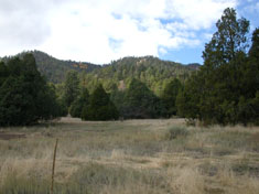
Meadow opening on north end of property The family emphasizes the public service component incorporated in this development. It proposes to develop a seven-mile long non-vehicular public access trail from Picuris Peak to Llano Quemado that follows the historic El Camino Real, along with a 2,000-acre conservation preserve. According to Barbee, there will be interpretive signs along the route that detail the history, geology, and environmental features of the land. Thinning and restoration work will provide fire protection, wildlife habitat, and a healthier forest. So far, all these plans are in the heads of the developers and their team of consultants, which includes Marron and Associates, who will be doing the archeological, fire, and environmental assessments and planning, Mary Ann Wasiolek, a Taos hydrologist, and a Santa Fe engineering firm. Barbee invited La Jicarita News and Cultural Energy to accompany him on a tour of the property so we could get a feel for the lay of land and what this proposed subdivision might actually look like. We entered the property on FR 476 off SH 518 (near Vallecitos), which will actually provide only emergency ingress or egress; the Weimer property boundary begins 1.1 miles from SH 518. The main entrance will be at the Llano Quemado end of the property, near the hot springs (which is currently administered by the Taos Land Trust). The property actually extends south from FR 476 to Picuris Peak, but the development will be located between this forest road and Llano Quemado. (See map below: the darker shaded area is the site of development.) A drilling rig was re-drilling a test well not far from the forest boundary when we drove by. Roy Cunnynham was standing on top of the rig, exemplifying the hands-on nature of the family's involvement in the project. This is one of six test wells that will be dug to assess the aquifer; each will need to pump at least 15 gallons per minute to be successful (one of the wells Barbee showed us, on the north end of the property, is artesian). The southern end of the property is largely ponderosa pine with some mixed conifer and piñon/ juniper. Barbee pointed out possible homesites, many of which will be clustered in appropriate areas (with less than 20 degree slope) and share a well. Before we entered Miranda Canyon (the current road is not the proposed access road to the properties) we took a closer look at the dense ponderosa, the result of clearcuts in the 1950s. Obviously, a lot of restoration work needs to be done to provide fire protection to the proposed community.
Weimer family representative Todd Barbee I asked Barbee why the family wants to spend so much time and money on a development of this magnitude: family members have obviously made a lot of money on previous land sales in the Taos area (the Weimer family owned all the land surrounding the hospital at the south end of town). His response was that this project is both economic and a legacy, not necessarily in that order. According to Barbee, the family "wants to prevent something from happening to this land that may not be appropriate." This is often the response to a question like that: if we don't do it right someone else may do it wrong, but it avoids the fundamental question of how much development of any kind is appropriate for an area like Taos, with a limited water supply and a unique cultural tradition. We entered Miranda Canyon where the vegetation changes to primarily piñon/juniper interspersed with meadow openings. Barbee showed us several meadows the family wants to preserve, and Robin Collier of Cultural Energy pointed out that active management practices like grazing or burning must be utilized to maintain forest openings. Barbee emphasized that because the master plan is still in the preliminary stages the family is open to all management ideas. While Barbee readily admits this is going to be a "subdivision for the rich", he continues to emphasize the public benefit of access and restoration of the property. He claims that some members of the Association "extorted this property for their own gain" and that the Cunnynham and Weimer families will be "responsible" developers, as they have been responsible members of the Taos community. La Jicarita News will follow the progress of this proposed development as a subdivision plan is submitted to the county and it conducts its review. The argument between the Cristobal de la Serna Land Grant Association and the Weimer family over ownership of the grant is predicated upon whether it was classified a private or community grant. The 1984 Selph v. Alger judgement stated that the grant "is a private land grant and that neither the Association nor its predecessors-in-interest have any standing to challenge the title of any person claiming title within the Grant boundaries." Historian Malcolm Ebright believes, however, that the loss of the grant "happened because the settlers on the grant had no protection under the Anglo tenure system for their use rights acquired under the Spanish system." He testified at the 1984 hearing that although title to the grant was in the name of one person, it was not a private grant nor a true community grant but rather a "quasi-community" grant, which is a grant made to an individual but operated like a community grant: individuals are given allotments of land for a house and garden but the remaining land is used in common for grazing, wood gathering, etc. As noted in the history of the grant, the New Mexico governor, in his revalidation, specified that the pastures and watering places were to be held in common. Alexander Gusdorf began buying up parcels of the grant as early as 1885 and continued as a land speculator through 1910, acting as an "Agent and Commissioner" for the grant. A land grant association that was predecessor to the Cristobal de la Serna Land Grant Association began challenging the Gustorf heirs over control of the grant in the 1930s; arguments among heirs to title in the association also erupted, and the stage was set for many years of contention over who should benefit from the land grant. A 2004 order from the New Mexico Court of Appeals rendered final judgement that the Cristobal de la Serna Land Grant Association has no right or authority to control Weimer Property. Former members of the Association have also acquired private holdings within the grant and have said they intend to develop them. Cristobal de la Serna was captain and commander of the Santa Fe presidio when, in 1710, he resigned his commission and sought a grant of land in order to support his family. On April 28, 1710 Governor Villaseñor granted Serna a tract of land in the Taos Valley that had previously been granted to another military officer and abandoned because of the Pueblo Revolt of 1680. Increased military activity, however, forced Serna to return to active duty and he was not able to take possession of the grant at that time. In 1715, when problems with nomadic tribes had subsided, Serna once again resigned his commission and applied to Governor Flores Mogollón for revalidation of the grant. The governor acceded to the request. Interestingly, despite the fact that this grant was being made to a private individual, the governor, in his revalidation, specified that the pastures and watering places were to be held in common. This seems to indicate that Serna intended to induce settlement in order to provide labor and increased protection for what was a remote and dangerous frontier outpost. Also of interest is the fact that Serna specifically requested that all of the officials from the neighboring Taos Pueblo be summoned so that they could voice any concerns or objections they might have had about the grant. Accordingly, on 15 June 1715 the lieutenant alcalde assembled all interested parties and, finding no objection to the grant, placed Serna in possession. The boundaries of the grant were: "On one side, the middle road and on the other side, the hot spring, and on the east, an old land mark, and on the other side, the mountain." Serna apparently occupied the grant until he was killed in a military action in 1720. His sons, Juan and Sebastian, sold the grant four years later to Diego Romero. Romero, seeking assurance of the validity of his title, requested a review by the territorial inspector general, Juan Paez Hurtado. In a document dated November 1724 Hurtado confirmed the grant's validity. Romero remained in possession of the grant until his death some time around 1764 when the grant was partitioned into three sections by his heirs. In 1795, some of the settlers on the grant, descendants of Diego Romero and others who had purchased tracts from the Romero family, applied for and received a supplemental grant called the Rancho del Rio Grande. This grant was requested for two reasons: first and foremost, the settlers on the Serna grant were dependent on the Rio Chiquito and the Rio Grande del Ranchito for irrigation purposes. The Serna grant settlers were concerned that if another group of settlers acquired this upstream tract, their water use would be impaired. Second, this new grant extended the community's common lands so that they could expand their livestock holdings. The grant specified that the pasturage was to be held in common and that the settlers must all acquire firearms within two years from the act of possession in order to protect the new grant from Indian attacks. In 1796 the heirs and descendants of Romero consented to relinquish all Serna grant lands situated between the Rio Don Fernando and La Cruz Alta in order that the Don Fernando de Taos grant could be made. From 1796 to 1876 the settlement continued to grow so that by 1876, when Juan de Dios Romero, José Dolores Mondragon, Lorenz Lobato and Vicente F. Martinez petitioned the surveyor general for confirmation of the grant on behalf of themselves and all other heirs, successors and legal representatives of Cristobal de la Serna, the grant contained over 1,500 settlers. |
|
 |
||

Home | Current Issue | Subscribe | About Us | Environmental Justice | Links | Archive | Index
Copyright 1996-2005 La Jicarita Box 6 El Valle Route, Chamisal, New Mexico 87521.